Filed Under Bearcreek

Smith Mine Historic District

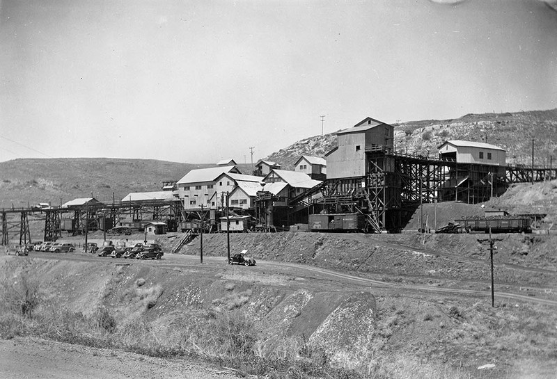
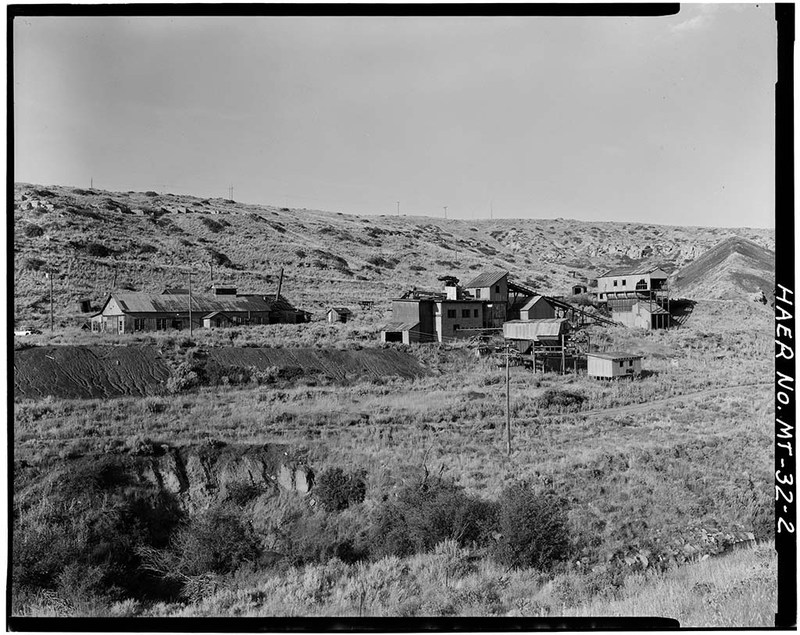
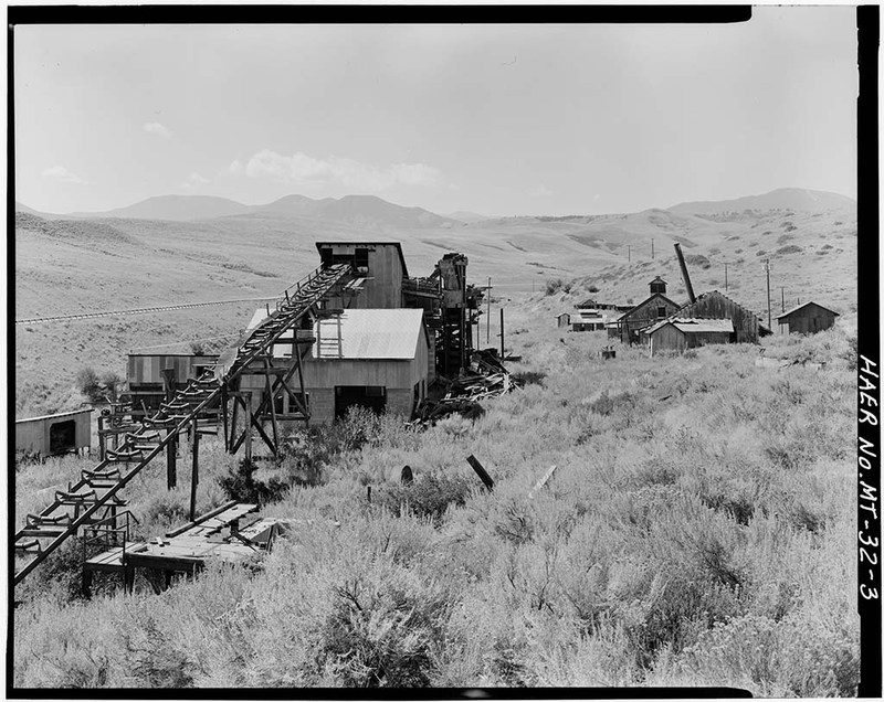
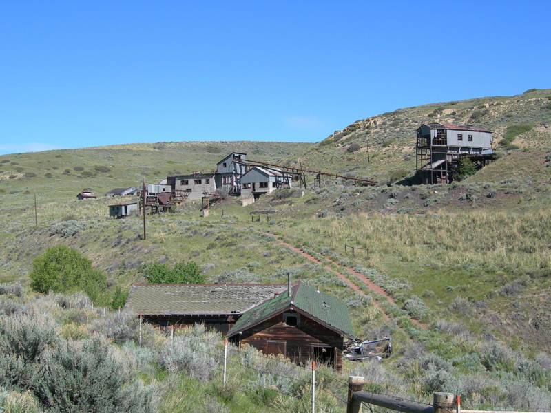
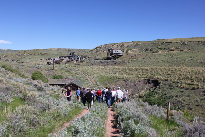
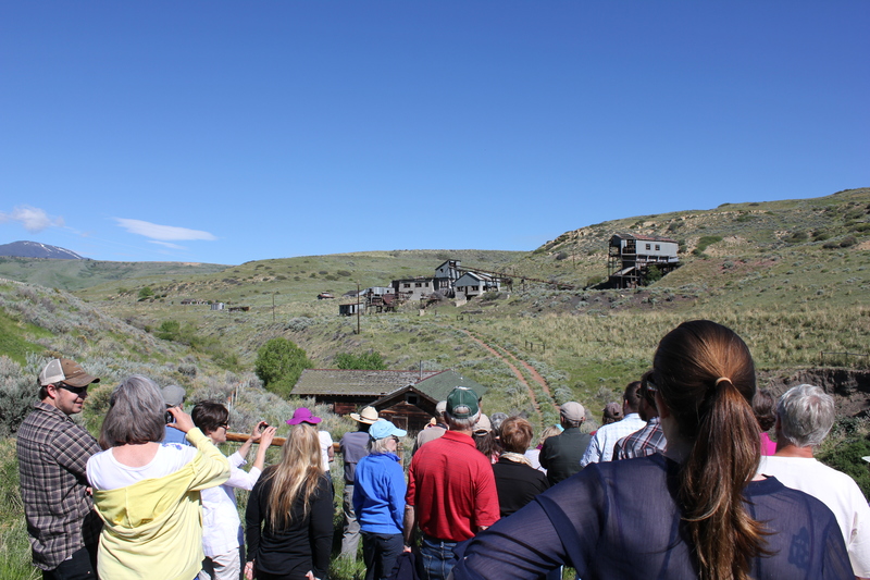
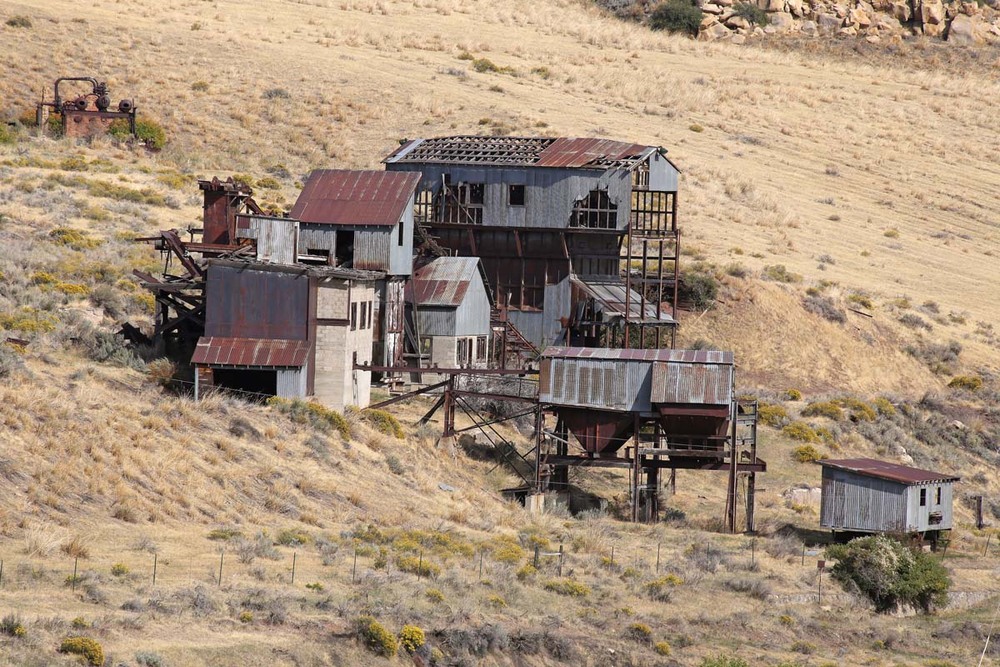
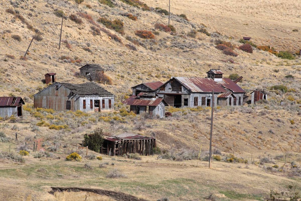
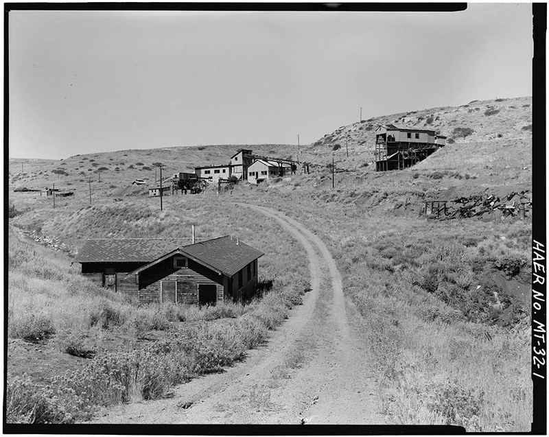
Thirty-nine corrugated metal structures mark the site of the Smith Mine, a ghostly reminder of a once vibrant mining district. The Montana Coal and Iron Company (MCI) began developing the Smith Mine in earnest after the arrival of the Montana, Wyoming and Southern Railroad, producing 8,000 tons of high-grade coal in 1907. MCI electrified its operation by 1915, completely mechanizing it by 1929. Throughout the 1930s, the company continued to invest in new equipment, building a new crushing plant, elevator, cleaning plant, coal sheds and scales, electrical substation, and other above-ground structures to support the underground operation. By 1943, miners working three shifts a day, six days a week produced almost 500,000 tons of coal annually, “to meet coal needs for a nation at war.” Investments in safety lagged behind other improvements, however, and in the 1940s many Smith miners still used open-flame carbide headlamps (as opposed to safer electric lamps). The highly gaseous mine also lacked good ventilation or rock-dusting equipment to control coal dust. On February 27, 1943, this proved a deadly combination, when a methane gas explosion in Smith Mine #3 killed seventy-four miners (and later, one rescuer) in the worst coal mining disaster in Montana history. Only three of the men working that day survived. Although MCI closed the Number 3 adit after the explosion, it continued to work its other mines, raking in record profits through 1945. Declining demand, lower quality coal, competition from diesel and natural gas, and bad management led to the operation’s closure in 1953.

Audio

The Smith Mine Disaster Audio recording about the Smith Mine disaster of February 27, 1943. Prepared and recorded by Montana Historical Society staff member Ellen Baumler. Presented on the Soundcloud channel "Montana History on the Go" 2017. Source: Montana History on the Go Creator: Baumler, Ellen Date: 2017

Images

Smith Mine, exterior
Smith Mine, exterior Lot 26 Mining Collection Smith Mine--Exterior Unprocessed Source: Montana Historical Society Research Center Photograph Archives, Helena, MT Creator: Unidentified photographer Date: [no date]
View of the Smith No. 3 Site Area to the Northwest
View of the Smith No. 3 Site Area to the Northwest View of the smith no. 3 site area to the northwest. The mine office building is in the foreground and the tipple and processing plant are in the background. - Smith Mine, Bear Creek 1.5 miles west of town of Bear Creek, Red Lodge, Carbon County, MT Digital ID: (None) hhh mt0168.photos.101280p Reproduction Number: HAER MONT,5-RELO.V,2--1 Source: Library of Congress Prints and Photographs Division 
Washington, DC
Creator: Historic American Engineering Record
Anderson, Paul, photographer
Date: Documentation compiled after 1968
View of the Smith No.3 Site Area to the Northeast
View of the Smith No.3 Site Area to the Northeast View of the smith no.3 site are to the northeast. The blacksmith/mine car repair shop is left center. The processing plant and tipple are right center. - Smith Mine, Bear Creek 1.5 miles west of town of Bear Creek, Red Lodge, Carbon County, MT Digital ID: (None) hhh mt0168.photos.101281p Reproduction Number: HAER MONT,5-RELO.V,2--2 Source: Library of Congress Prints and Photographs Division Washington, D.C. Creator: Anderson, Paul, photographer Date: Documentation compiled after 1968
View of the Processing Plant to the West
View of the Processing Plant to the West View of the processing plant to the west. The processing plant is left center. The blacksmith/mine car repair shop and parts/supplies buildings are right center. - Smith Mine, Bear Creek 1.5 miles west of town of Bear Creek, Red Lodge, Carbon County, MT Digital ID: (None) hhh mt0168.photos.101282p Reproduction Number: HAER MONT,5-RELO.V,2--3  Source: Library of Congress Prints and Photographs Division Washington, D.C. Creator: Anderson, Paul, photographer Date: Documentation compiled after 1968
Untitled
Untitled
Untitled
Smith Mine
Smith Mine Photo of structures. Source: Montana Historical Society Creator: Tom Ferris, Photographer Date: 6 October, 2021
Smith Mine/ Bearcreek Cemetery
Smith Mine/ Bearcreek Cemetery Photo of grave in cemetery. Source: Montana Historical Society Creator: Tom Ferris, Photographer Date: 6 October, 2021
Smith Mine
Smith Mine Photo of structures on hill. Source: Montana Historical Society Creator: Tom Ferris, Photographer Date: 6 October, 2021

Location

The Smith Mine historic district begins at the gate at the southeast corner of the site and proceeds in a northwesterly direction along the Right-of-Way (ROW) fence to where the fenceline turns 90 degrees to the north. From here, the boundary moves away from the fenceline and crosses the coulee to intersect with a two-track road. The boundary then turns again to the west to include the Cameron House at the far southwest corner of the property. From the Cameron House, the boundary follows the contour of the hillside to the north until it reaches the powder magazine located at the head of the coulee. From the magazine the boundary crosses the coulee eastward following the contour of the sandstone outcropping. The boundary then follows the edge of the sandstone rims in a generally easterly, then northeasterly direction until it reaches a point above the power plant. From here, the boundary follows the irregular outline of the reclaimed area to the east, then south, then west on the north side of the coulee to meet the two-track road. From here the boundary continues southeast to the gate and the place of its beginning. Bearcreek, Montana | Private

Metadata

The Montana National Register Sign Program, “Smith Mine Historic District,” Historic Montana, accessed April 25, 2024, https://historicmt.org/items/show/20.